Islamic geographers: al-Idrisi’s map of the world (1100s AD)
Universities in the Islamic Empire
Silk Road and Indian Ocean trade made many people in the Islamic Empire rich enough to send their sons to college. So the big university at Alexandria in Egypt stayed open. But the university moved from Alexandria to the nearby town of Fustat, which we call Cairo.
The University of Alexandria
University of Fez
Medieval Islamic science
All our Islamic Empire articles
A new university also opened up in Baghdad. Baghdad was another new city, near ancient Babylon (in modern Iraq). There were also smaller Islamic universities in Tunis (in Tunisia near ancient Carthage), Cordova (Spain), Fez (Morocco), and other cities.
Better world maps

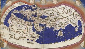
A copy of Ptolemy’s map of the world
At all of these universities, geographers kept working on drawing better maps of the world. They built on the work of the earlier Egyptian geographer Ptolemy. They talked to travelers and traders to find out what the world looked like. Then they used these facts to draw better maps. For example, Islamic geographers knew that the Pacific Ocean lay on the other side of China.
Who was Ptolemy?
A medieval Islamic map of the world
Can you see how al-Idrisi’s map represents Europe, Asia, and Africa? Look at it carefully. North is toward the bottom of the map. The big land mass at the top is Africa. Under Africa to the right is the Mediterranean Sea, and below that is Europe.
Geography of Europe
Arabian Peninsula
African geography
Under Africa to the left is the Indian Ocean. And between them is the Arabian Peninsula. At the far left are India and China. Compare this map to a modern map. Is the medieval map accurate? Would it be useful to travelers?
Al Idrisi and Ibn Battuta
One very famous Arabic-speaking geographer from North Africa was al Idrisi, who worked in map-making (among other things) in the 1100s AD. In the 1300s AD, there was another famous North African geographer. His name was Ibn Battuta.
Learn by doing: draw a map of the world today and compare it to this medieval map
More about al-Idrisi
More about Ibn Battuta
